Saturday, July 16, 2016

Mount Belford and Mount Oxford, July 8-10, 2016

Mount Belford

El: 14,197'
Route:  Northwest Ridge to Summit
Trailhead: Missouri Gulch, 9,640'

Mount Oxford
El: 14,153'
Route: West Ridge
Trailhead: Missouri Gulch, 9,640'

Total Evelvation Gain: 5,967' feet
Distance: approx. 10 miles

I enjoyed my trip to Castle Peak, Conundrum Peak and Mount of the Holy Cross so much in late June that I was in a big hurry to go back to Colorado to bag some more 14ers.  I did a few things differently this time.  I left my crampons, ice ax and helmet at home, for a non-technical Class 1 ascent.  I also opted to seek out a route that would easily fit into a day, removing the need for overnight backpacking to approach the peaks.  The 14ers vary wildly in their difficulty.  Some require lengthy approaches, while others are close enough to the trailheads to be managed easily in a day. Some are easier "walk-ups", while others are scrambles and are dangerously exposed.  I sought out some peaks that were on the easier end of the spectrum for this trip, but as all 14ers present some degree of challenge, each are worthy of attention.  I also brought along my friend Alicia, in hopes she could complete her first 14er.  In this case, I decided upon Mount Belford and Mount Oxford, which are known for their straightforward nature.  Due to their close proximity, both peaks are usually climbed together in one day.

Day 1, July 8, 2016. Alicia is relatively new to her explorations of Colorado, So we took our time to enjoy the scenery. She really enjoyed taking photographs of the Sangre de Cristo mountains near the towns of Crestone and Alamosa as we drove North.  We also made a side trip to Colorado 82 to enjoy Independence Pass, where ascending hairpin turns and drop-offs with no guardrails produced some involuntary yelps from Alicia as she leaned out the passenger window to take photographs of  high peaks in the majestic Sawatch Range.  At the top of the pass at an elevation of 12,090' we were in love with the temperature, which was in the low 60's- an incredible relief after the record-setting temperatures of June and July in New Mexico.

Alicia at Twin Lakes, on the way towards Independence Pass.
The exciting switchbacks along Independence Pass.
A small lake at the top of Independence Pass. Somehow, it felt awkward to work so little to see such beauty.
After some pleasant walking and picture taking at Independence Pass, we drove to the Missouri Gulch Trailhead on Chaffee County Road 390, west of US24.  The popularity of weekend hiking on the 14ers in Colorado became readily apparent.  Arriving as late as we did, sometime after 7:00 PM, we were lucky to find a campsite, just as another car had left.  The day use parking lot at the trailhead was completely full.

The most enjoyable element of our car camping site was our proximity to clear creek, which muffled the sounds of vehicles rattling over the dirt road, and helped lull us to sleep after we ate some dinner, (which was made possible by a loaner lighter from another hiker) as I had actually forgotten any kind of firestarter for my stove!

Day 2, July 9, 2016.  We had a 4,600' relentless ascent ahead of us over only 3.5 miles to attain the summit of Mt. Belford.  In my typical style, we were awake by 3:30 AM and we broke down our tents, packed the car and drove about a 1/4 mile east to the trailhead.  at 4:03 we donned our headlamps, crossed Clear Creek, and ascended the notorious switchbacks up into Missouri Gulch.  At about 10,800' we somehow missed the creek crossing to the east, or left side of Missouri Gulch and found ourselves a little off-route on a boulder field as we continued to ascend on the west side of the gulch.  But some headlamps on the other side of the gulch helped us locate the trail on the correct side and we found another place to cross the creek.

Close to 7:00 AM we reached the base of Mt. Belford at 12,000 feet, where Alicia could tell she had already reached her limit as far as her acclimatization went.  She found a relaxation spot on a large, flat boulder to enjoy herself for the rest of the morning.  She encouraged me to continue.  In a way, her time was more productive, as she saw cute wildlife from her vantage point, yielding many great photographs.

Photograph showing the North West Ridge of Mt. Belford, the ascent route.
I ascended the remaining 2,100 feet of Mt. Belford in a brisk 80 minutes, and arrived on the summit at 8:20 AM.  The popularity of this route was very apparent, as it was hard to take photos without people in the composition.  Hundreds of people must have stepped foot on the summit that day.  I enjoyed the top of Mt. Belford for about 25 minutes before heading for Mount Oxford at 8:45 AM.  I descended down to the Mt. Belford and Mount Oxford saddle at 13,500 and ascended the West slope of Mount Oxford, and arrived at the summit by 9:35.  After another 25 minutes I was on my way back to Mount Belford, which had to be re-climbed in order to return to Missouri Gulch.  The east ridge return on Mount Belford is slow-going for most hikers, who have already reached two summits in a day.  The steepness and rockiness of this portion of the route tested my endurance a little.  At 10:50 I reached my final high point for the day, and could put all the uphill slogging behind me.

It was hard to miss the people in most shots!


An extremely uplifting early morning view of Missouri Mountain, elev. 14,067' as I neared the top of Mount Belford.

At the summit of Mount Belford!
At the summit of Mount Oxford!  I'm a little more tired in this photo.
Based on a recommendation from a hiker the day before, I decided to return via the much more gentle route via Elkhead Pass between Mount Belford and Missouri Mountain to the West.  It was a great decision.  The azure sky and a view of wide-open rolling slopes of green tundra, speckled by wildflowers, was soothing to the soul.  In about another hour I had returned to Alicia at 12:00 PM, who was beaming after spending several relaxing hours in what she called "my mountain paradise", which included some visitations by pikas and marmots.  We enjoyed a great lunch on the boulder, and I must say that the saltiness of Triscuits with hummus never tasted so good.

Elkhead Pass in all its wildflower glory!

The early afternoon heat was sweltering as we descended Missouri Gulch.  The steepness and exposure of the switchbacks could be fully appreciated now, and also, their relentlessness.  By 2:00PM we reached the car.  We had an upcoming trip to Princeton Hot Springs as motivation to keep moving.

We finished off the day at Princeton Hotsprings, where I had been just two weeks earlier and enjoyed the creek side pools and water slide.  All aches and pains found relaxing relief from the water.

Next, dinner was on the mind.  The Colorado crowds had not abated since we left the hike.  A handful of the better restaurants in Salida had 90 minute waits, so we had to settle on a funky pizza place, DePasquale's, where we ordered a veggie pie that was probably more cheese than bread, but was awesomely fullfilling.

I was too worn out to drive another 4 hours south back to Santa Fe, so the hunt was back on to find camping sites.  Thanks to Google, I was able to track down a forest road, Country Road 101 off of US 50, which after great searching produced a campsite.  Again, it would have paid off to begin looking for a camping site earlier.

Alicia at the campsite for our second night.

Day 3, July 10, 2016.  By 7:00 AM we were in the car an on the way back to Santa Fe.  Lessons learned from this trip included avoiding 14ers on mid-summer weekends whenever possible,  look for camping early in the day, and look for easier routes to help all members of the party acclimate.  In retrospect, Mount Sherman, often touted as the "easiest" 14er would have been a better option for Alicia to have found success,  Regardless, it was an fun experience over these three days!


Wednesday, July 6, 2016

Conundrum Peak, Castle Peak and Mount of the Holy Cross, June 23-25

Conundrum Peak

El: 14,060'
Route:  Conundrum Couloir to Summit
Trailhead: Castle Creek, 11,160'

Castle Peak
El: 14,265'
Route: Northwest Ridge
Trailhead: Castle Creek, 11,160'

Mount of the Holy Cross
El: 14,005'
Route: Angelica Couloir
Trailhead: Halfmoon Campground, 10,320'

Net Evelvation Gain over three days: 8,970 feet
Distance: approx. 18 miles over three days.

It may have been almost five years since I climbed my last Colorado 14er, but it is a passion of mine not forgotten. I'm whittling away at the list one peak at a time, with the goal of climbing each one. Living hundreds of miles to the south in New Mexico makes it a tedious goal, as trips to Colorado are sporadic, and time is limited, but this is one goal I'm convinced I'll achieve by some unknown date in the future.

I'm excited to finally have reports for three new 14er peak climbs completed in just a three day span, on June 23-25, 2016! For each of them I was able to take advantage of early summer snow pack and ascend them in my favorite way, with mountaineering boots and crampons on my feet, ice ax in my hand, helmet on my head, and headlamp illuminating the path in the darkness of early morning, while snow is solid and grippy. The rest of this entry will be about these three peaks, unofficial 14er Conundrum (14,060'), Castle Peak (14,265') and Mount of the Holy Cross (14,005')

I had a fairly ambitious itinerary planned in order to take advantage of the little time away. My small family, including, my partner, Alex and our wonderful dog, Cheyenne, were both a little sad to see me leaving!

The morning of Day One, June 23 was spent driving to Aspen, Colorado, where I continued on the Castle Creek Road and passed the small town of Ashford in the Elk Mountains. Eventually, the pavement ended and a rough 4WD took its place, which I followed to my starting point in the Land Rover. It is actually one of the highest roads on a Colorado 14er, topping out at an incredible 12,840', slightly beyond the abandoned Montezuma mine. The road is too rough for most vehicles past 11,160', which is the point at which I parked the car, just after a narrow wooden bridge crossing over Castle Creek. The road up to this point was exciting enough, especially with the previous creek crossing, which had no bridge for vehicles, and required fording the high water of the creek fed by ample early summer snow melt.

Hiking Along Castle Creek Road towards my Castle and Conundrum Basecamp

I started hiking at 3:06 PM, and arrived at the end of the road at 4:45 PM, stopping in between for just a ten minute break. The sunny weather deteriorated and the wind picked up. Thunderclouds and rain began to threaten. I had wanted to continue further, but I decided to camp at a flat, rocky bench with an easy-to-access water supply, and wait out the weather. It ended up being a good decision, because it turned out that I'd be on continuous snow the next morning for my snow climb up Conundrum Peak, which really wasn't too far away by now. The storm sounded worse than it was, and the evening was capped off by an incredible rainbow extending between Malamute Peak and the slopes of Castle Peak.

Stunning rainbow over Malamute Peak as seen from my campsite at 12,820'
Day Two, June 24. This was about to be a very, very long day, which started long before sunrise. The most challenging thing about attempting a snow climb is the unusual schedule. After gearing up for my climb, I started under the moonlight at about 2:50 AM. I had been stirring for most of the night in anticipation, so I was actually quite antsy to get moving at this time. The early start accomplishes two things: you take advantage of snow being firm, which is best for cramponing, and the second is the incredible opportunity to watch the sunrise mid-climb, or if you are lucky, on the summit, itself!

I made my ascent of Conundrum via the exciting Conundrum Couloir which started at 13,500' and rose over 450 feet. The snow was steep (nearly 45 degrees at the top), but it was wonderfully consolidated. My crampons gripped the snow well and I used the self-belay technique with my ice ax for added security. Still, a fall here would be scary, which became evident when my Nalgene water bottle slipped out of my pack and careened hundreds of feet down to the bottom of the couloir in mere seconds. Many trip reports on Conundrum spoke of a gnarly cornice at the top, but it had melted down enough at this point that I was able to bypass any unstable, overhanging snow by going to the right.


Funny enough, I quickly understood the reasoning behind the name of the peak while on or near the summit. At the top of the couloir were two ridge points (one to the left and one to the right). I climbed up to the right point first, thinking it was the highest, which I reached at 4:40 AM, only to look at the other summit and believe it was higher. I reached the other point at 5:11, where I ended up taking my traditional summit selfie, only to realize the map indicated I was on the wrong summit and I was right in the first place, but as it isn't marked correctly on all maps, I'm STILL not entirely sure! Quite the conundrum. At least I stood at the top of both, so I was at the “true summit” at one point, whether the photo proves it correctly or not. Regardless I took my time here to enjoy the sky filling with pink prior to sunrise.

My Conundrum Peak Summit Selfie, somewhere on the top (not sure if it was the true summit or not!)
Hints of pink light begin to fill the sky over Castle Peak, as viewed from Conundrum Peak

From here, I descended Conundrum Peak's South Ridge and ascended Castle Peak via its Northwest Ridge. On the ridge top there was very little snow to contend with, and crampons were stowed away for safekeeping. I arrived at the summit of Castle Peak at 6:25. The views of the rising sun over Malamute Peak and the lake in the snow-filled basing between Castle and Conundrum Peak was breathtaking!

I recently start learning Gimp, and I combined several exposures into this shot to create an image that I felt really showcased the beauty of the sunrise between Castle and Conundrum.

I stayed at the summit of Castle Peak for nearly 20 minutes, until I was satisfied with my selfies and scenic photos! I descended Castle's Northeast ridge trail, which had enjoyable, gentle switchbacks leading to the lake, which I reached at 7:30 AM. It was on this stretch that I met the only other people I would see on this trip, a young couple, who were ascending the Northeast ridge route. The basin was small enough, it didn't take long to relocate my missing water bottle which was perched in the edge of the lake. The water was quite chilled and was a refreshing thing to return to. I snapped some more photos before arriving back to camp at 7:50 AM, five hours to the minute from my departure time. By 8:35 AM I had broken down camp, repacked my backpack, and started back on foot down the Castle Creek Road. I was to the car by 9:20 AM. A lot had already happened, but the day was still young!

The mandatory Castle Peak selfie!
On the descent of the Northeast ridge of Castle Peak, looking back towards the small lake below Conundrum Peak.  Conundrum Couloir is the inset notch above the lake between the two ridge points that make up the peak.  What a fine snow climb it was!
Wildflowers with Castle Peak and Moon in the background.
Last look at Conundrum Couloir from the retrieval spot of my missing water bottle at the edge of the lake
I started driving back down the rough road when the low coolant level warning went on. “Oh, no” I thought, “I must have hit a damaging rock on the way up,” even though I had been so careful. When I stopped to check it, there was NO coolant in the reservoir at all. With a 15 mile drive back to Aspen and no cell reception, I was a little anxious, to say the least, and not too thrilled that my plan to head to Holy Cross would be delayed, at best.

I made an unexpected detour to Aspen Total Automotive, where the mechanics were very willing to check out the damage even without an appointment. It turned out the culprit for my coolant leak was likely a very BIG rodent- a marmot, perhaps, who had a taste for heater hoses. The Land Rover's heater hose was completely chewed through. The mechanic fixed it with a hose camp and coupler, and within an hour or two I was able to start the next adventure, albeit a little later than expected.

I drove out of Aspen to the northern portion of the Sawatch range near Vail. I traveled South past the town of Minturn on highway 24, before driving up the uneven Tigwon Road for about 8 miles to the West, where I parked at Halfmoon Trailhead, the most common starting point for climbs on Mount of the Holy Cross, a peak which gets its name for a majestic couloir on its east face that is intersected by a snow ledge two thirds up before the summit, giving it the appearance of a cross. Considering its unique appearance, it is one of the more famous of the Colorado 14er's and is an extremely popular summer climb

It turned out that my adventure was really just beginning at this point. In retrospect, I'd prefer attempting the harder peak on my itinerary first, but in this case, my ascents of Castle and Conundrum peaks were really just a warm up for Mt. Of the Holy Cross, which would be a much bigger challenge for me. Seeking an alternative to the well-worn standard North Slopes route, I sought out a challenging, seldom-climbed snow route for my ascent, Angelica Colouir. Most snow climbers will seek out the longer, more committing “cross couloir” on the East Face.

Due to all the driving time, delays, and my low energy level, I didn't get started from Halfmoon Trailhead until 5:12 PM. The challenge of this peak was immediately obvious, as I ascended from 10,320' to Halfmoon Pass at 11,640' in just 1.7 miles. In the next 1.4 miles, I lost 975 feet of the hard-earned elevation when the trail descended to the Cross Creek campground. The pass contributed to the difficulty level of this hike, considering the near 1000 feet would have to be regained on the way out.  However, rewarding views of Mt of the Holy Cross, and my objective climb, Angelica Colouir, made up for the added effort.

My first view of Mt. of the Holy Cross.  The large snow field in the notch to the right of the peak would be the next day's objective, Angelica Colouir.

I arrived at the Cross Creek campground at 7:00PM, which consists of 10 pre-designated camping sites. I still had plenty of of daylight to set up camp at site #5, and enough time to scout out the start of the faint climber's trail which would lead on a steep ascent to the south for the next day's snow climb. The rugged nature of Mt. Of the Holy Cross is often underestimated, and it took some time to find the correct route, which began between campsites #3 and #4 and just to the west of a small beaver pond. A party of two, Rich and Mike had the goal of climbing the cross colouir the next day. The two of them had significant trouble scouting out the trail, and Mike had gone off on his own for hours to search.  Rich became worried and assumed him to be lost.  Loud calls of "Mike!" were met with no answer.  He was concerned enough when Mike wasn't back by nightfall, that he called search and rescue, who would deploy the next morning to look for him. He was at neighboring campsite, #4, I believe I faintly heard Mike returning later that night and talking to Rich.  I assumed all ended well, because there was no sign of SAR the next day. The best advice I can offer anyone climbing Mt of the Holy Cross via Cross Couloir or Angelica Couloir, or any of the other non-standard routes is to budget extra time for the route-finding. There is enough traffic, especially on weekends, that it is easy to find another climber to partner up with. And route-finding is always easier with an additional brain set to the task. Another climber, by the name of Travis, arrived at campsite #6 and I was happy to run into him the next morning.


Day Three, June 24. After another restless sleep, I was awake at 4:15AM and left camp at 4:44AM, a much later start than the day before, and, in retrospect, too late a start for today. I ran in to Travis shortly after 5:00 AM on the climbers trail I discovered the night before, and for the first hour or two of our ascents we stuck together. His objective would be the Cross Couloir farther to the south. Above treeline the trail became practically non-existent and we split at this point and I headed towards the northeast-facing rock-filled gully below Angelica Couloir, while he headed to a high lake called the Bowl of Tears, below the Cross Colouir. From what I had heard, my chosen route was known to be more direct, and had fewer objective challenges than the more famous Cross Couloir. Given my energy level after completing a climb just the morning before, I felt this was a better alternative. I soon discovered that this did not mean in any way that it would be easy!

The ascent up some rocky gullies towards the start of Angelica Couloir

The challenging route finding resulted in me not starting the snow climb until 7:54 AM. By comparison, I would have already been back at my base camp the morning before! The snow was soft enough that crampons were unnecessary, but kick stepping was a required technique on the near 1200 vertical feet I was about to ascend on a very steep slope. The couloir split at about 12,900' and I took the southern branch up the final 800' to the ridge crest, where I picked up the North Ridge Trail after finishing on a couple hundred feet of unpleasant rock debris. The sun was beaming down the whole time, I was sweaty, and I was tired. The entire couloir ascent took until 10:30 AM, provided no reliable spot to take a break,  no place to retreat in the shade, and the snow was getting increasingly soft.  All the factors made me feel very sluggish compared to my typical pace, which is about 1000' per hour. All I can say is that this is a serious undertaking. Leave early. Leave early.  I'd have enjoyed myself much more without the hot sun and if I could have used my crampons on firmer snow.

Finally at the start of the 2.5 hour snow climb ahead.  I was pushing 8:00 AM at this point, a late start to be on snow in late June.
I took very few photos from within the Colouir.  At 45 degrees, and surrounded by potential rockfall zones I wanted to limit my time in there as much as possible.  This photo shows where the couloir split.  Over another 800 vertical feet were still ahead.
At 10:50 AM I finally reached the summit of Mt of the Holy Cross, and found Travis who had already completed the Cross Couloir. The route-finding challenges were no easier for him, and his summit climb didn't begin until 9:00 AM. One added plus to the route he picked is that the snow was continuous the the summit, whereas I had to finish with climbing on talus and boulder-hopping for the last 300 vertical feet along the main route. I concluded that Angelica Colouir was in no way more direct, but it could have been a misconception based on my less-than-stellar energy level.  Still, I was thankful to have not gone to the Cross Couloir.

From the notch at the top of Angelica Couloir.  After 2.5 hours on a 45 degree slope it felt amazing to sit down on some flat ground.

My Mt. of the Holy Cross Summit Shot.  Thank you Travis!

I took quite some time to enjoy the incredible views from the summit, especially since the weather was still beautiful. There was some cloud build up, but nothing to worry about. I descended 3,700 feet over three miles back down to camp via the North Ridge Route, which was well marked with large cairns and a trail constructed beautifully by the Colorado 14er Initiative, which even had large rocks laid out to form stairs in the steep areas. There were no hidden challenges here other than the rapid descent.

This photo really displays the steepness and ambitiousness of the Angelica Couloir climb.  It is the long middle couloir, angling slightly to the right.

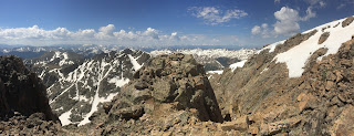
I took a moment for a little scenic photography along the North Ridge Trail.  the weather was still magnificent.
I arrived back to campsite #5 at 1:35 PM, where I spent the next three hours eating, re-hydrating and napping before repacking my bag and heading out of camp by 4:30 PM. The 975 foot hike back up to Halfmoon Pass loomed ahead. I reached the top of the pass by 5:23 PM and was back at the car by 6:10PM. I was thankful that no rodents had made lunch out the the Land Rover this time.

I drove back to Vail, where I had dinner at Qdoba. I found an area to park the car that night, where I reclined in the passenger seat and slept for a few hours before waking up at 4:00 AM on June 26 to drive back to Santa Fe. I treated myself to a soak at the Princeton Hot Springs, which I visited for the first time nine years ago, which was a much-needed way to rejuvenate myself before going home.

The most poignant aspect of any wilderness trip like this one is the perspective you can bring back with you. I'd like to conclude this entry with thoughts I wrote down shortly after my return to Santa Fe.

Sometimes in life you may stumble off the well-worn path for minutes, hours, days, weeks or even years, which can be agonizing when you encounter many obstacles, including the dead ends and moments of failure. But this doesn't mean you can't ever return to the path you were on, or even discover new paths. Surely life would be easier if you'd never lost your path, but imagine all the places you never would have gone, all the people you never would have met, and all the things you never would have done had you not gone astray. In fact, the repeated act of losing the path was the very thing you had to do to get where you are now. Be prepared to accept those times in the future when you stumble off the path and embrace those times of uncertainty and hardship, and know that through this process great discoveries will be made.

Friday, May 25, 2012

Castle Peak trip goes afoul

One of the most important things to remember about mountaineering is that reaching the summit is never a guarantee.  When variable factors come in to play, like the human element, weather and snow conditions, each constantly changing, luck must be on your side.  I've been turned around from numerous 14er's now, including the Wilsons, Quandary, Handies, and now Castle and Conundrum.

In this case I only got as far as the Trail head.  May 23 was a rainy and cold day in the Elk Mountains and I hardly felt invigorated as I started this trip.  Optimistic that the weather would clear, as predicted, I proceeded, anyways, and drove down Castle Creek Road to the road for Pearl Pass and set up my tent during a break from the drizzle.  I ate dinner, and following my usual routine, I set the alarm for 3am and go to sleep.  The pit-patter of rain on my tent serenaded me to sleep.

The cell phone alarm somehow failed to work, but I instinctively wake up at 3am to dead silence.  "Oh yes!" I thought.  "The rain has stopped!"  Sure enough it had, but the story doesn't end there.  I slowly rose to a seated position and my head contacts the roof of the tent which feels extremely heavy.  "Oh no!  There's snow on my tent."  I started beating the sides of the tent and the snow slid off in large, soggy clumps.  I felt around for my headlamp, turned it on and unzip the tent to peer around.  Sure enough, the headlamp lit up a keleidescope of snowflakes pummeling down.  Already, six inches were on the ground. 

Remembering how poorly my Honda Civic performs in snow, especially the wet stuff, I haphazardly repacked the car, threw down the tent.  I drove out of there, and that became the end of my Castle Peak adventure.

C'est la Vie!

Wednesday, May 23, 2012

Snowmass Mountain, May 21, 2012

Snowmass Mountain
El: 14,092'
Route:  Snowmass Creek approach, east slopes route to summit
Trailhead: Maroon Snowmass
Elevation Gain: 5,800'
Round Trip mileage: 23 miles


After climbing a handful of 14er's that were easy to access, each being no more than a day-hike, and requiring very little technical challenge, I decided it was time to push my limit again.  Feeling thoroughly
warmed up after my previous string of six summits, I fixed my attention to Snowmass Mountain in the Elk's range, which would be a mileage-intense backpacking trip, including an 17 mile round-trip approach and 5 mile roundtrip summit route.  Of all the peaks I've climbed, Snowmass Mountain provided a diverse number of challenges, ranging from a long backpack hike, significant elevation gain, deep post-holing in snow, steep snow-climbing, exposed ridge scrambling and a rather unpleasant scree descent, making it among my most celebrated Colorado summits, in good company with Kit Carson Peak/Challenger Point from last year.  There were moments of the climb that even felt reminiscent of Mount Hood and Mount Rainier, especially considering the ungodly hour at which I had to begin my summit bid, and the donning of crampons, helmet, head lamp and iceaxe.

The long approach hike began at the Maroon Snowmass Trailhead at about 3:30 PM along Snowmass Creek, and entered a stunning valley, which cuts southward through the Elk's range.  For those seeking a less-extreme adventure, this trail affords a great day-trip.  The route takes you along roaring white-water of Snowmass Creek, through glistening aspen groves, and across reflective beaver ponds.

Entering the wilderness boundary.  A reminder that you are going to a beautiful place.

From a view point, snow-clad peaks of the Elk's come in to view

Beaver' are actually true artisans, creating this beautiful reflective pool for my enjoyment.

Crossing over a beaver pond to regain the trail on the other side

 The ponds would be a great turnaround point for day-hikers, as the difficulty increased from here.  In several switchbacks, the trail made a hearty accent towards Snowmass lake, and the post-holing fun began.  The trail, obviously not as well maintained from here, required several scampers over fallen trees.  Overall, the difficulty was moderate, but after 7 miles of hiking with a heavy pack for the first time this summer, the last push to the lake was not enjoyable.  My instinct in bringing snowshoes paid off within the last half mile of the lake where the post-holing became a pretty consistent occurrence.  It was near here that I discovered I was not alone, and met a very friendly couple all the way from New Brunswick: Russel and Nicole, slowly making their way through the snow slog.  I was surprised they had heard of Snowmass Mountain, but they obviously did their research, and planned a trip which would take them to one of Colorado's most incredible mountains.  Once I reached the lake, along with my new friends, the tribulations of the afternoon quickly washed away as we were greeted with a stunning alpine setting at the edge of Snowmass Lake.  Still light at 8:00 PM, the first order of business was to photograph the scene.  Choosing camaraderie with fellow hikers over solitude, we pitch our tents close to one another and spend the evening regaling one another on our adventures as we set up our tents and eat our dinners.  Before bed, we discuss our differing ideas on our route choices to the peak.  At about 10 PM we are all in bed and Alarms are set for about 3 AM.
Ah, yes!  How magical it is to be in the one place you most want to be at this moment!  Snowmass Lake.

Thank you Russel for the photograph.

The infamous scree-field at the east end of the lake.  I opt to take the continuous snow chute on the left of the scree-slopes.  It looks quite intimidating from here.  Russel and Nicole opt to stay on the rock.


There is never anything fun about waking up while it is still dark and feeling groggy from lack of sleep, to go climb a mountain in the cold.  It is something that must be done out of necessity.  But trading sleep deprivation and cold temperatures over a daytime post-holing nightmare and potentially dangerous wet snow slides is always the wiser choice.  The beginning of the summit morning was arduous and madenning!  At 3:30AM, I was the first to leave camp, and I made my way to the first obstacle, the stream crossing, a mere 15 yards or so from camp.  Still tired and fumbling around, I didn't maintain balance on a log, and splashed in to the water about knee deep, completely soaking my boots!  I returned to camp to switch in to drier socks, but the damage was already done.  I would spend my whole day with wet feet, argh!  After my false start, things didn't get any easier as I had to traverse along a snowbank on the south side of the lake, it's angle constantly wanting to pull me in to the water.  The only thought in my head was "why am I doing this?"

My morale improved as the sky lightened and I started to make out the silhouettes of the peaks, finally getting a visual reference beyond the scope of my head lamp.  I made my way to the snow chute I was eye-ing the evening before, relieved to discover it wasn't nearly as steep as I thought and it ended up being a great alternative over the standard route up the scree.  The rising sun coincided nicely with me rising to the toe of the namesake snowfield on the east face of Snowmass mountain, which indeed is absolutely massive!  From here the snow climb relented in steepness and became very pleasant on the solid snow of early morning and my crampons purchased wonderfully.  This was the most relaxing, meditative section of the whole trip, where I fell in to my groove and pacing.  Gazing in to the morning alpenglow, the negative thoughts of that morning quickly washed away.

Nearing the edge of the "snowmass", overlooking the lake.

Alpenglow on Snowmass Mountain (right)

The sun arrives to warm my day.

The steep face of Snowmass Peak (not to be confused with Snowmass Mountain) seen to my left.


Snowmass Mountain, however, still had some tests in store for me.  Closer to the ridge, the slope angle steepened once again and the snow, having been in direct sunlight for a couple hours, was quickly deteriorating into a slushy mess.  I decided to follow the snow nearer to the peak summit rather than heading out of it sooner, south of the peak and along the ridge.  I reached my crux, a 6-7 foot tall snow cornice which I stabbed with my ice axe.  After a couple committing steps I popped out on top of the ridge, to be greeted with an outstanding view of the majestic Elk's Range, which came with the price of significant ridge exposure.  From here I removed my crampons, set down the iceaxe and proceed north up a class 3 scramble to the ridge summit, arriving at 7:56 AM.  I took my usual set of photos, and, after spending no more than about 15 minutes on the summit, I made a very slow, meticulous down climb off the summit, regathered my gear and traversed along the ridge to a snow ramp that made for an easier snow descent.

So close to the ridge now!  The cornice on the left side is my final crux move.

Another view of the cornice, adorned with icicles.  Yes, it was quite steep!

BAM!  Now on top of the ridge the view comes on forcefully

Sitting below the summit rock.  I had to set a self-time for this.  10 seconds wasn't enough to climb the rock. :(

View of "North Snowmass".  On a day with better snow stability I would have climbed this, too.


Before 9:00 AM the snow up top was already trash and I was quickly post-holing on this steep slope.  I also became aware of a new hazard, hidden rocks underneath the snow, which absorbed warmth from the sun, creating a void in the snow.  I dropped in chest-deep at one point.  While still soft, the snow gradually improved as I climbed further down, and plunge-stepping most of the way, travel started to become much more efficient.  I spent the whole morning wondering about the progress of Russel and Nicole and I finally see them arrive on the snowfield not long before 9:00AM.  Their choice to climb the scree field must have cost them some time.  They summed it up in one word: "miserable".  After a few minutes involving a couple sitting glissades and more plunge stepping, I quickly reach them.  I quickly fill them in on the adventure thus far, and report on the snow conditions.  They make the decision to continue on until the post-holing became too great, an inevitability, I told them.

I made it back down the snowfield in what seemed like no time.  Not wanting to descend the chute I climbed up. I headed down the scree-filled gully, intermixed with snow, back to the lake.  There wasn't much to say about it, other than it's unpleasant nature, already mentioned.  It felt warm, and comfortable at the east shore of the lake and I took some time to chow down on some salty and sweet snacks before I made that awful traverse along the lake again, involving more post-holing, of course.

I hated this snow bank along the lake, but it was the only way to and from camp!  I keep my iceaxe in hand the hole time.  While a slide here was of low consequence, a slide in to the recently thawed lake would have been extremely unpleasant.

Panoramic view of the lake.  Snowmass mountain crowns the large snowfield on the left. 

Back at camp at 11:00 AM, I ripped my boots, wet socks, and gators off as quickly as possible and listened to my feet sing "Hallelujah!"  I assembled my gear to dry, and laid out in the sun to thaw out. I fell asleep in my tent for a couple hours.  After growing restless, I unziped the fly and clambered out, just as Russell and Nicole are returning.  The report: they turned around not far below the ridge as soon as the post-holing reached the chest-high level.  And their verdict?  "We'll be back again!"

We chatted for awhile, ate more food, rested our feet, and I soon started packing up all my belongings to make the trip back down, turning a long day in to an extremely long day.  I start walking out at 3:30 PM and arrive back at the car around 7:00 PM.  I traded out my now very uncomfortable leather boots for flip flops and drove to the Glenwood Springs Hostel, my crash pad for the night.  Would I go climb Snowmass Mountain tomorrow?  No.  But someday will it warrant a second trip? Absolutely!

The car!  I'm done!

Oh, and let's not forget our honorary guest appearance by my friend Gilbert!  Yes, I habitually give names to marmots while hiking.  If you don't like it, well, I guess you shouldn't be hiking with me.


Tuesday, May 22, 2012

Mount Democrat, Cameron, Lincoln and Bross, May

Mount Democrat, Cameron, Lincoln, and Bross
El: 14,148', 14,238', 14,286, 14,172, respectively
Route:  Ascended northeast slope of Mt. Democrat, descended west slope of Mt. Bross
Trailhead: Kite Lake
Elevation Gain: Aprox. ?
Round Trip mileage: ?
Start Time/Finish Time: 6:15 AM/ 1:30 PM


After hiking seven 14er's in 7 days, the exact details of each climb are starting to fade.  So, before more time passes, I thought I would report on my climbs of Mount Democrat, Cameron, Lincoln and Bross, near the small town of Alma, perched at 10,580 feet, where they claim to have the "Highest Saloon in America" and about 20 miles south of Breckenridge.  From the center of Alma, a dirt road (CR 8) travels Northwest about six miles to Kite Lake at 12,000'.  In all my years of hiking I have never found a trailhead at higher altitude.  This one is even complete with an outhouse.  Following my usual routine of establishing a base camp and rising early to take advantage of frozen, consolidated snow, I spent the night at the lake, which, was also the highest point I had ever slept, beating my previous record of 11,700 feet at Lake Katherine near Santa Fe, New Mexico.  The Kite Lake basin affords a great view of Cameron and Bross.  Democrat is the left-most peak, but its actual summit is hidden from view.  Lincoln, tucked behind Cameron is completely obscured.

Kite Lake Trailhead, at 12,000' where I set up camp and rested for my summit bids the next day.
 I woke up on May 18th at about 5:30 AM to do my first snow climb of the season up Mt. Democrat.  Normally I would get moving much earlier than this, but the cold temperatures were keeping the snow rather stable throughout the entire morning.  The steepness was moderate, and after dealing with the loose rocks in the Sawatch Range, I thoroughly enjoyed the snow and getting used to my ice axe and crampons again.
After beginning my snow climb on Mount Democrat and overlooking still-frozen Kite Lake
The southeast face of Mount Democrat.  Still a ways to go!
Higher up this time, looking down at my snowy path below
When I gain the ridge, the view of Mt. Democrat's actual summit comes in to view
 I'm  not entirely remembering my summit time on each of the peaks, but I believe I made it to the Summit of Mt. Democrat around 8:30 AM.  Despite sleeping lightly the night before, and substantially less oxygen going to my brain, I had there mental where-with-all to throw in my political $0.02.  As of yet, I don't know of any "Mt. Republican" that compels a climb.
I did just summitted "Mt. Democrat" and this somehow seemed fitting

From Mt. Democrat, There is a complete view of Mount, Cameron, Lincoln, and Bross, aligned nicely along the ridge to the east.  The route was completely straight-forward, with no difficulty exceeding easy Class 2.  This is by far the easiest place in Colorado to bag multiple peaks in a day, four in this case. (This is, if you include Cameron, which is not an officially ranked 14er, but is still listed in the Gerry Roach guide book.)
Descending the east ridge of Mount Democrat and steadily making my way towards Mount Cameron
I had to loose a fair amount of my hard-earned elevation as I descended Mount Democrats's connecting ridge to Mount Cameron, and then regain it to make the next summit.  The climb, in general was quite chilly and often breezy, but I had a short respite while ducked behind some rocks on Mount Lincoln and the temperature rose briefly.  It was a fine place to take an extended break, especially being the day's highpoint. 
On the Summit of Mount Lincoln, the highest point of the day
 Once I left Mount Lincoln, the wind along the ridge to Mount Bross was terrible, gusting up to 60mph, I'd guess.  I encountered a sign on the way to the summit, which bars access to the top,  but I decided to ignore it because I wasn't previously aware of any red tape, and I reached my last summit of the day at exactly 12:00 PM, a perfect time to descend. 
Yes, I saw the sign.  Yes, I read it.  And yes, I still went.
 The descent route was confusing.  There were the remains of multiple mine shafts amongst the scree and a criss-cross of old roads.  I follow one of these roads and realize quickly that I am off route as it leads in to a deep gully.  Uninterested in regaining the trail which was high above me, I followed the gully down to the Kite Lake Basin, finding a few opportunities to do a standing glissade in the snow.  I reach the car at about 1:30 PM, rest for awhile, disassemble my tent and drive away.  I stop at the saloon in Alma for a delicious Greek pizza and at a coffee shop for a hot chai, before leaving for Breckenridge, where I stayed the evening at the Firehouse Inn.  The next day I planned to climb Quandary peak, the one 14er of the Ten-Mile Range, but the weather had other ideas.  I woke up to gray skies, rain, snow and wind.  I was also teased by intermittent bursts of sunlight through the clouds.  I decided it was a good day to rest, and I quickly started planning my upcoming climb on Snowmass Mountain.  
Looking up the descent route.  It was not exactly "pleasant"